
Notes on the history of the
|
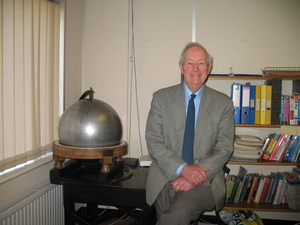 Photo taken 07 March 2008 |
A Personal View from Robin Adams
Received: 25 March 2010
Introduction
Although written in the third person these notes are my purely personal memories, and are particularly concentrated on the time since my involvement with the Centre from 1964. Where appropriate I have tried to include my own personal recollections and interpretation o f events at the time – these may not always be wholly accurate! For the sake of completeness brief summaries of early history and recent developments have been included. Mr David McGregor has provided much information about the earliest days of the Centre and the development of its computing systems.
The International Seismological Summary, 1922-1963
Various attempts at global earthquake location had been made since the end of the 19th century. Foremost among these was the work started by Professor John Milne at his home at Shide in the Isle of Wight, and continued after his death in 1913 by Professor Turner at Oxford University. Funding was mainly provided by grants from IUGG and the British Association for the Advancement of Science (BAAS). Various other institutions also produced global bulletins, in particular the centre at Strasbourg, which later became known as the Bureau Central International de Séismologie (BCIS).
 |
 |
|
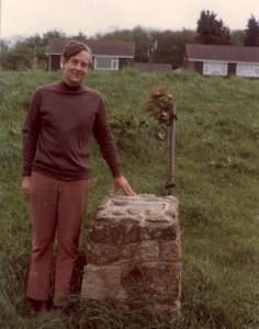
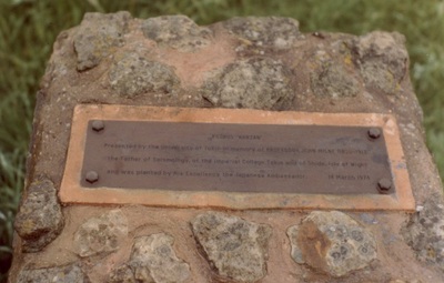
| Dr Robin Adams at the Milne’s memorial, May 1979. | Milne Plinth, Shide, Isle of Wight, with a tree Prunus "Kanzan". The inscription reads "Presented by the University of Tokyo in memory of Prof. John Milne (1830-1913) the Father of Seismology, of the Imperial College Tokyo and of Shide, Isle of Wight and was planted by his Excellency, the Japanese Ambassador. 14 March 1974." |
In an attempt to regularise the situation and improve the results, the International Seismological Summary (ISS) was formally set up in 1922 by the newly-formed International Union of Geodesy and Geophysics, to carry on the work of international earthquake location.
The ISS continued to produce its bulletin of global earthquake locations, with ever increasing scientific standards as new methods and knowledge of earth structure became known. In 1934 the first travel-time tables of Harold Jeffreys were used in the analysis of earthquakes of 1930. In 1946 the ISS came under the control of the UK Meteorological Office and moved to Kew, and from 1948 the full Jeffreys-Bullen tables were used in the analysis.
There was a new development in 1961, however, when Professor Bruce Bolt successfully demonstrated his new computer location program to find a location for the deep Spanish earthquake of 1954. This program was used by ISS for its analysis of earthquakes from 1954.
During this time the ISS had a succession of eminent Directors, such as Sir Harold Jeffreys and Dr Robert Stoneley, who acted mainly in an advisory and supervisory role, while the day-to-day analysis was undertaken by a small, dedicated, permanent staff. Particular contributions were made by Miss E F Bellamy, and Mr J S Hughes, who worked as computer and analyst at ISS from 1923 until his death in 1965.
Establishment of the International Seismological Centre, 1964
New interest developed in reliable earthquake location in the aftermath of the Second World War, through the need to detect and identify nuclear explosions. In particular the US Coast and Geodetic Survey set up the World-Wide Standard Seismograph Network (WWSSN) in the early 1960s, and carried out a global earthquake locating service. There were, however, political difficulties in achieving full exchange of data, and interest grew in strengthening an internationally controlled service. The ISS, still at Kew, was continuing to experience financial difficulties and was falling further behind in its analysis.
Early in the 1960s UNESCO, being aware of these difficulties and wishing to help in the problem of international earthquake location, called an international meeting to consider the setting up of a body to collect and store world-wide seismological information and produce definitive bulletins of relocated earthquakes, and their associated station readings. Thus a centre was established in the autumn of 1963, with significant funding from United States and United Kingdom, to take over the earthquake relocation tasks of the ISS from 1964. The founding Director, Dr P L Willmore, initially used the title International Seismological Research Centre (ISRC), but following comments from the scientific community that research was an inappropriate activity for the new body, the ISRC became the International Seismological Centre (ISC). It was to remain in Britain, but to be internationally controlled, with no political ties. As well as publishing a regular monthly Bulletin of the ISC and a six-monthly Regional Catalogue of Earthquakes, it was to act as a collection centre for all seismological data and compile a Bibliography of Seismology. At this stage the funding was still very uncertain, with support coming from IASPEI, some national agencies and UNESCO itself.
Dr Willmore was at that stage head of the Seismological Research Group of the Royal Observatory, Edinburgh, and continued to hold his position there, while also acting as Director of the ISC, which moved to nearby premises at 6 South Oswald Road in June 1964. The ISS continued to work from Kew for a few years, with Dr Willmore now also its Director, until the remaining staff moved to Edinburgh about 1967. The final two years of ISS analysis, for data years 1962 and 1963 were published from the ISC in Edinburgh in 1968 and 1969 respectively.
Early Analysis at Edinburgh
Dr Willmore’s great area of expertise was seismological instrumentation, including designing while a research student at Cambridge, the eponymous short-period seismometer that became extensively used throughout the world. In addition, as was common at that time, he tended to believe implicitly any results generated by a computer, irrespective of their physical implications. From the outset he insisted that the ISC operation be entirely computer oriented, and requested all data be submitted in computer-readable form, with the analysis being undertaken entirely by computer. At the beginning, the assembly of the data and the creation of the punched cards for printing the bulletin was done at the Bank of Scotland. Computers at the Bank of Scotland continued to be used for most, if not all, of the time that the Centre was based in Edinburgh.
Dr Willmore’s faith in the power of new computing systems was rather excessive, and he provoked some ire by publishing in 1963 a paper “A Strategy for Seismology”, in which he claimed that global earthquake location could be performed adequately by a limited number of sensitive seismometers concentrating on short-period recording only, and specifically claimed that there was no need for extensive local networks. Although theoretically sound, these claims could not be borne out in practice. He also considered that the only magnitude determination necessary was that from the short-period vertical P-wave arrivals, and the input format for data submitted to the Centre had provision only for the ratio of amplitude to period of these phases. This restriction was to limit the usefulness of the Centre's data collection until long-period amplitude and period data were accepted from 1971, and only used fully in the determination of surface-wave magnitude from 1978.
Despite Dr Willmore’s views, it was agreed that ISC wait two years before starting its analysis in order to make its data files as complete as possible, bearing in mind that at that time communication was very difficult with remote stations such as those in the polar regions and on remote islands, which were vital to provide good global coverage. After some initial difficulties the Bulletins of ISC appeared monthly, and have remained the definitive global earthquake listings ever since.
Data were submitted to the Centre by post, either on punch cards, on paper or magnetic tape or by telex, and in the early days, the information was sent for scientific computation on magnetic tape, initially to a commercial bureau in Birmingham, and later to the Atlas Laboratory in Chilton in Oxfordshire (although the Rutherford Laboratory IBM computers were mostly used). Some insight into procedures of this period are given in a paper published in the Proceedings of the Royal Society in 1966.
The first ISC bulletins produced, for the first months of 1964, were quite unacceptable. A new computer program had been devised, and its early version produced many errors in analysis, mainly by associating readings from earthquakes in different parts of the world into a single fictitious event, and by interpreting later phases as first arrivals. Some foci were assigned negative depths, which Dr Willmore justified as reflecting the errors in models and observations. A computer error assigned some epicentres latitudes greater than 90°. Later improvements, including a closer scrutiny of results by analysts, led to these difficulties being overcome and the defective bulletins were re-issued, with more realistic solutions. The Centre’s programs were completely rewritten over the next few years, largely by Dr E P Arnold, based on work he had done as a student of Sir Harold Jeffreys. After leaving Cambridge he was attached to the US Coast and Geodetic Survey, from where he was given leave to work at ISC. Tony Marshall, from the United States, developed an editing program to allow interaction with the computed results. Anatoli Levshin incorporated software developed in Moscow to allow identification of later phases, and Graeme McNair wrote software to deal with the collection of the data.
The early issues of the Bulletin included only events for which other agencies had determined parameters. It was only after the arrival of Dr S J Gibowicz, from Poland, as Deputy Director in the late 1960s that previously unreported events were included in the Bulletin. Initially these events were selected by visually scanning the unassociated data and adding initial estimates of the location to the data stream. Later, the NEIC in Golden provided a copy of their program for finding events from a stream of arrivals and this was incorporated into the ISC procedures.
Re-establishment of ISC
In the late 1960s there was still a lack of proper funding arrangements, so UNESCO called a further meeting of national representatives at the Madrid IASPEI Assembly in 1969 to discuss putting ISC on a firmer footing. Delegates at this meeting were not keen to set up an official inter-governmental body, but rather opted for an independent Non-Governmental Organisation to be established under Scottish law at Edinburgh. These new ISC statutes allowed for a Governing Council of representatives from national seismological agencies that subscribed at least a minimum subvention. The first meeting of the Governing Council was held at the Royal Society, London, in November 1970, with representatives present from subscribing organisations in six countries, viz. Canada (Dr J H Hodgson), New Zealand (Dr R D Adams), Soviet Union (Prof N V Kondorskaya), Sweden (Dr O Dahlman), United Kingdom (Dr H I S Thirlaway) and U S A (Dr R E Hanson). In addition there was a representative from UNESCO and observers from several other countries that later became members. The first Chairman of the Governing Council was Dr J H Hodgson of Canada, and at this meeting it fell to him effect the replacement of Dr Willmore as Director by Dr Arnold. This task was particularly painful for Dr Hodgson, as Dr Willmore had previously served for a time on his staff at the Dominion Observatory in Ottawa. A small Executive Committee was set up under the Chairmanship of Dr Thirlaway. Mr A A Hughes, son of Mr J S Hughes, who had already been working with his father at ISS, was appointed Deputy Director.
The Governing Council next met at the Moscow IUGG Assembly in 1971, by which time the number of members had increased significantly. It has since met regularly at least every two years, and has now grown to include representatives from more than 50 countries and agencies. Initially the Royal Society, London, provided secretarial services for the Governing Council, specifically in the person of Mr C R Argent, who continued in this post after his retirement until the mid 1990s. It is also important to note the great contribution of UNESCO to the setting up of the Centre in its present form, and for providing financial support in the early years. It was they who called initial meetings and provided guidance in all aspects of the centre’s activities. In particular, Dr E M Fournier d’Albe, the founding Director of the Division of Earth Sciences, was the UNESCO representative on the Governing Council, on which he played a prominent role. Although an atmospheric scientist by speciality, Dr Fournier d’Albe had acquired a sound knowledge of seismology while working with Dr Thirlaway at Quetta Observatory in Pakistan.
Dr Arnold continued to effect substantial revision of the Centre's procedures and analysis programs. Despite restrictions from limited funding, these programs were remarkably efficient in all aspects from data storage to producing tapes for the final printing of the Bulletin, and it is a great tribute to Dr Arnold and his staff that they remained essentially unaltered until the 1990s. Nevertheless, the computer’s output continued to be carefully scanned, using the expertise of analysts to override false associations and interpretations.
As the volume of data being submitted to the Centre increased, it became increasingly inconvenient to ship punch cards back and forward to the Rutherford Laboratory, so it was decided to seek a closer base in Southern England. An obvious choice was Newbury, in Berkshire, only 15 miles from Rutherford, and also close to Dr Thirlaway’s government unit for forensic seismology at Blacknest near Aldermaston.
Move to Newbury, 1976
Approval for the move to Newbury was given at the Governing Council meeting at Grenoble in 1975, and thus over several months late in 1976 and early in 1977 the Centre moved from Edinburgh to rented premises at Clarendon House in London Road, Newbury, and bought a small van so cards could taken to and from the computer at least daily. Soon after arriving in Newbury, on the suggestion of the Atlas Laboratory, the Centre acquired a computer (GEC 2050) to act as a workstation and allow a number of devices in the ISC office to communicate with the Rutherford computer via a landline.
At the time of this move the Centre’s permanent staff comprised four. Dr Arnold was Director, Mr Hughes was his Deputy, Mr D M McGregor was in charge of computing, while Mrs B Scott-Barrett was the librarian and bibliographer. In addition there was a seismic analyst from the Philippines, a data punch operator, a secretary and a handyman/driver. At this stage, the Centre moved its academic affiliation from the University of Edinburgh to the University of Reading. Such an affiliation was necessary to channel the grant from the U S National Science Foundation. Reading University provided the services of Mr J Mulholland from its finance department, to act as the Centre’s Finance Officer, and also handled the Centre’s salary payments. In return for this service, the Centre was to fund a Research Fellow in the University’s Geology Department.
In August 1977 the Governing Council met in Newbury following the IASPEI Assembly at Durham. At this time there was still serious concern over the Centre’s long-term future, particularly financial, and difficulties associated with its lack of legal status. Three possible scenarios were mooted: one was to move to Geneva, and be closely affiliated with, or even part, of World Meteorological Organisation, the second was to move to Vienna to a new science centre being developed by the Austrian government to house other organisations such as the International Atomic Energy Authority, while the third was to remain as an independent Non-Governmental Organisation in Newbury. Eventually, the third option was to prevail.
At this meeting it was also announced that Dr Arnold was being recalled by the US Geological Survey, and the Governing Council appointed Mr A A Hughes as Director, initially for a two-year term. It was realised that Mr Hughes at this stage was still relatively inexperienced, and the Chairman of the Governing Council, Prof Stephan Müller, therefore asked Dr R D Adams of New Zealand to come to the Centre to act as “special consultant” for a period. Dr Adams arrived in March 1978, and eventually decided to remain permanently, until his retirement in 1995, during which time he also held the post of ISC Research Fellow in the University of Reading. Dr Adams was not heavily involved in the Centre’s administration, and at the IASPEI Assembly in 1979 he was elected Secretary-General of that organisation, a post he held for the next twelve years. During this period he was often able to combine interests of IASPEI and ISC, and elicit new members and data providers for the Centre. At a special Governing Council meeting in London in May 1978, Mr Hughes was confirmed as Director, and Mr McGregor as his deputy.
Analysis Procedures, 1980s and 1990s
Over the next years the Centre continued to expand its membership and improve its services. In particular, the growing development in computing power allowed additional and more efficient analysis. In addition to Mr Hughes and Dr Adams, at least one seismic analyst from an outside agency was employed, generally for a two-year term. Mr McGregor also benefited from computing assistants. With the continuing expansion of the global recording network the amount of data submitted to the Centre grew substantially. In 1978 a typical month’s data comprised 38,000 readings, leading to 1,500 located events, by 1995 these figures had grown to 140,000 and 6,000. An important part of the Centre’s output was the new “search” events, found from readings unassociated with earthquakes already located by other agencies. By 1995, about 130 such events were detected each month, often in regions remote from national networks, or where no individual network had enough readings to determine a solution on its own. The basic procedures of the Centre’s analysis in this period are described in a paper “Analysis Procedures at the International Seismological Centre” published in 1982.
Throughout this period events were analysed in monthly batches, with every event being scrutinised, and any necessary changes made through successive passes of batch analysis. Procedures were constantly being honed. Dr Adams introduced procedures to interpret crustal phases, and use these even when not the theoretical first arrivals, and Mr McGregor devised new and speedier methods of encoding editing changes. The increasing number of events precluded the examination of each individual observation, but analysts developed skills at visually scanning a page of computer output, with the eye picking out any unusual pattern in distances or residuals. Computer-generated messages also highlighted any unusual pattern of readings or events. Difficult events were sometimes subjected to graphical investigation on special station maps developed by Mr McGregor. With practice, the editing process became very speedy, and if no difficulties were encountered, up to 100 events an hour could be scanned. Dr Adams used to continue editing at home in evenings and week ends, sometimes even while watching TV, leaving more office time free for research and other activities. Obviously some errors remained, but with practice the level of errors could be kept to “an acceptable minimum”.
There was also continuing improvement in methods of collecting and handling data and in computer methods. Initially, in the 1960s data were requested either on paper or magnetic tape, or else on mark sense cards that could be automatically scanned. However in order to be as complete as possible, there were always some data that had to be entered directly from station bulletins. With growing technology more data arrived on tape, by now magnetic, or by telex, and then with the advent of the internet an increasing amount arrived by electronic mail.
Early in 1982 the Centre acquired its own computer, a VAX 11/750, and the need for the daily run to Rutherford was reduced as the programs were set up. This machine was replaced with a new model some years later. By the beginning of 1983, 90% of the Centre’s processing was being done in house. Thereafter, the Centre could have moved to any location, but by now was conveniently established in Berkshire.
Move to Thatcham, 1986
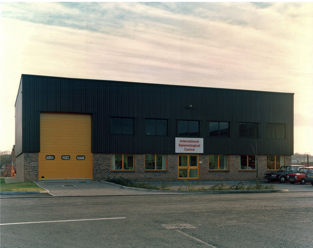
By the early 1980s the Centre’s scientific programme was operating well, but there still remained financial difficulties. A major outlay was the ever increasing charge for rent and maintenance for the offices in Newbury, so a search was undertaken for new premises. No suitable existing property could be found either to buy or rent, so in 1985 the Governing Council meeting at Tokyo authorised the purchase of a plot of land on an industrial estate in Thatcham, a few miles east of Newbury, and the building of its own premises there. The building was designed to house not only offices, but storage for all the Centre’s stores and archives, which previously had been kept in additional rented space. The purchase was financed by a mortgage, which was denominated in US dollars to reduce the impact of exchange rate changes.
The move was made in October 1986. Initially, there were only enough funds for a single storey of office accommodation within the building’s shell, which resulted in much sharing of office space, with only one room for the all the seismic analysts and the library, and one other for the computing staff. Fortunately, these cramped conditions did not last long, and a second storey of office accommodation was occupied early in 1989.
|
| ISC building as first aquired, circa 1986 |
Academic Affiliation
At the time of the Centre’s move to Newbury, the Department of Geology at Reading University was headed by Prof P Allen F.R.S, an eminent and able scientist with broad interests, under whom there was an active geophysics section run by Dr C McCann, who also became the University’s representative on the Centre’s Executive Committee. There was an excellent undergraduate course in Geological Geophysics, in which Dr Adams lectured on observational seismology; he was also involved in some postgraduate supervision. Throughout the 1980s there was much re-organisation of science in British Universities, and support for earth physics was gradually withdrawn from Reading. By the time of Dr Adams’s retirement in 1995 there was no undergraduate teaching there in earth sciences, and the Department had been re-designated as a Postgraduate Research Institute in Sedimentology. It thus made sense to transfer the Centre’s academic affiliation to the University of Oxford’s Department of Earth Sciences, and in particular to draw on the expertise of Prof John Woodhouse, a theoretical seismologist of some renown, who took up the academic position on the Executive Committee. This connection still exists.
Recent Developments
Mr Hughes continued as Director until the end of 1997, during which time the Centre continued to function smoothly and efficiently, with the procedures being continually improved. Among the changes made were the issuing of the Bulletin on CD-Rom, and with the help and advice of Prof Woodhouse the Centre began to move its computing systems to UNIX-based SUN workstations. On his retirement, Mr Hughes’s services were recognised by the award of an O.B.E. (Officer of the Order of the British Empire).
Mr Hughes’s successor was Dr R J Willemann, who continued the modernisation of the Centre’s activities, both in the computational and analysis fields, implementing new techniques that were becoming available and making use of the expansion of new technology. In particular, the ISC website and an Oracle Relational Data Base were established, and after the UNIX system was installed the VAX was soon pensioned off.
These improvements were continued under Dr A Shapira who was Director from 2004 until 2007, and more especially by Dr D Storchak, who assumed the Directorship in 2008.
Advances in the power and flexibility of new computers mean that the Centre’s present procedures are vastly different from those of a few decades earlier. Data input comes almost entirely by electronic means, although formats still need to be carefully checked. There is much interactive editing done directly on the computer screen, and automatic coding of editing commands replaces tedious key punching. There is provision for later arriving S phases to be included in the analysis. New data are submitted to the data base as they are received, and if need be can be provisionally analysed ahead of the final analysis, and various earth models may be tested. The Centre now routinely employs the ak135 earth model instead of the Jeffreys-Bullen model used during the initial decades. However the Centre also continues producing locations based on the Jeffreys-Bullen travel-time tables in the automatic mode with rather limited subsequent review.
Throughout the world new methods of digital recording and data transmission have been developed, often resulting in automatic phase picking, replacing the conventional visual reading of analogue recordings. This means that there has been a virtual explosion in the amount of data submitted, and events stored. By 2005 an average of 320,000 readings a month were received, resulting in about 22,000 listed events, of which some 4,000 were reviewed. Better coverage by national networks now results in only about 10 to 15 new events being found each month.
The distribution of the Centre’s results has also been revolutionised. Originally the printed publications were the main output. This was a costly process, consuming a substantial proportion of the Centre’s resources. As it became more practical for users to access the Centre’s output online, the printed versions of the publications have been greatly reduced. Now the Bulletin of the ISC is published only every four months, containing only summary data of all reviewed events, while results of the Centre’s full analysis are freely available online.
The Centre is now not only the repository of past data, but is becoming more involved in international seismological projects and contributing to the development of seismology at all levels. Further major changes are envisaged to make data even more speedily available and tailored to the needs of modern-day seismology.
Bibliography
Adams, R.D., Hughes, A.A. and McGregor, D.M., 1982. Analysis Procedures at the International Seismological Centre. Phys. Earth Planet. Inter. 30, 85-93.
Adams, R.D., 2002. International Seismology. In International Handbook of Earthquake and Engineering Seismology. Part A. (W.H.K. Lee, H. Kanamori, P.C. Jennings and C. Kisslinger eds). Academic Press, London (for IASPEI). 29-37.
Fluendy, A., McGregor, D.M. and Willmore, P.L., 1966. The Collection of Seismic Station Readings. Proc. Roy. Soc.A, 290, 461-466.
Rothé, J-P., 1981. Fifty years of history of the International Association of Seismology (1901-1951), Bull. Seism. Soc. Am., 71, 905-923.
Willmore, P.L., 1963. A Strategy for Seismology. Geophys. J. Roy. Astr. Soc., 8, 242-248.
Other stories on the ISC history