
The Role of non-IMS Stations in Explosion Monitoring
Ray Willemann's talk at the Vertic seminar
during the CTBT Article XIV Conference of 2003
Seismology has always required sharing data across broad geographical
regions. Indeed, some people assert that British seismologists from
the early part of the 20th century were outstanding in the field
partly because demanding data from various parts of the British Empire
was quicker than negotiating data exchange agreements. The International Seismological Centre was created in 1970. Part of
its original mission was to take full advantage of the then new World
Wide Standardised Seismograph Network (WWSSN). But the ISC was also
charged with collecting data from other seismic observatories that
collected data relevant to global earthquake monitoring, and creating
an integrated analysis of all WWSSN and other available data. The
ISC's structure is very different than the IDC's. The ISC relies
heavily on the work of individual observatories and regional networks,
and principally integrates their regional or preliminary analyses into
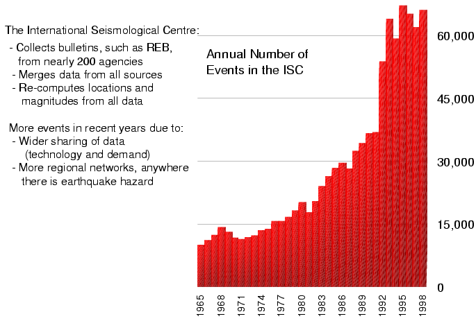
a coherent global summary. The ISC's work has grown over time, as technology has made it
straightforward to share an ever-growing volume of data and as more
regional seismic networks have been installed. The growth also shows
that seismologists have remained true to their original ideal of
generously sharing data. Rather than try to pick out individual
periods of rapid growth, I tend view this figure as generally
exponential growth, followed by almost no growth at all from 1994 to
1998. The lack of growth in those years reflects the limited
capability of the ISC; there was no slow down in either the volume of
data collected or the willingness of seismologists to share their
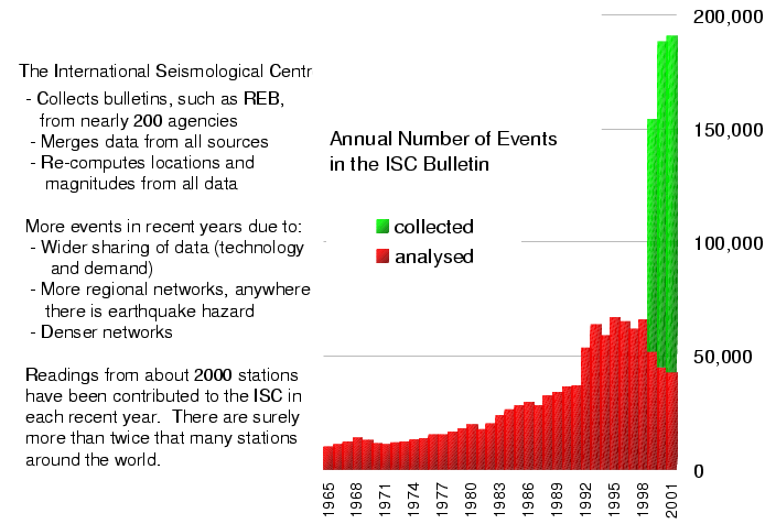
data. In adding data for further years, I have changed vertical the scale in
order to show the much larger number of events for which the ISC has
collected data in recent years. The red bars in this chart for 1965 to
1998 represent the same numbers as in the previous chart. The change from 1999 onward is that the ISC has re-organised its own
system, so that we can collect information and re-distribute it to
seismologists while manually reviewing data for only selected events.
The points of this chart are that seismologists continue to share data
freely and that the volume of data continues to grow exponentially.
The ISC now bases its analysis on data contributed each year from more
than 2000 seismic stations. Based on my regular discussions with
seismologists around the world, I believe that at least twice that
many seismic stations are operating. Some seismologists reckon that
within a few years there might be 10,000 seismic stations operating
all around the world. Apart from the CTBT International Monitoring System, a large majority
of seismic stations are installed as part of seismic hazard analysis
and mitigation programmes. (A few hundred are installed in global
networks for academic studies of earth structure, and these networks
include stations in aseismic, unpopulated regions.) The rise in the
number of mega-cities in seismically active areas is startling,
accelerating, and likely to compel further advances in collecting and
analysing seismic data. How useful are all of these seismic stations in monitoring for covert
underground nuclear explosions? To put the question very
provocatively, does the enormous growth in the number non-IMS seismic
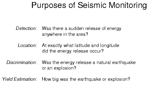
stations make the IMS pointlessly redundant? The question should not be answered simply yes or no, because seismic
monitoring has several purposes. We want to know whether or not
"something happened", where the something was, what the something was,
and how big the something was. This division is somewhat arbitrary. Knowing that something happened
implies at least a general idea of where and how big it was, and
knowing just where and how big it was is often useful in know what it
was. Still, breaking things down like this helps to answer questions
about the monitoring roles of seismic data from various stations. Those of you who have been involved in CTBT affairs may have seen maps
of global detection thresholds, which show the size of the largest
earthquake or explosion that might not be detected. Non-IMS stations
can improve detection thresholds in an obvious way: near a seismic
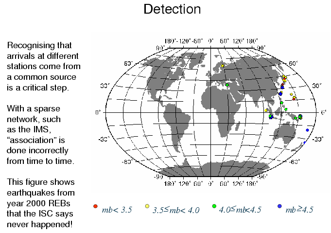
station an explosion must be smaller to evade detection. I want to describe a different sort of contribution that non-IMS data
can make to detection. One of the first steps, and it is a very
crucial step, is recognising that signals at several different seismic
stations all come from a common source. This step is challenging
partly because a small earthquake that happens to be near an IMS
station can produce a signal at that station, even though it is
smaller than the detection threshold, and so fails to produce a
visible signal at any other IMS station. In analysing IMS data, computer programs and human analysts at the IDC
might incorrectly suppose that signals at several different stations
come from one common source when, in fact, the come from various small
sources near each of the stations. This is a problem for any seismic
network with a limited number of stations spread across a wide area.
IDC seismologists are alert to this problem, but in some cases the
only way to recognise such an error is to have more data from stations
near the source that has supposedly been detected. This is not simply a theoretical problem. There are 44 earthquakes in
REBs of year 2000 that the ISC later concluded did not exist. ISC
seismologists found that when they reviewed data from, say, numerous
stations of the Japan Meteorological Agency, there were no signals
from an earthquake that the IDC said was near to Japan. There are
grounds for discussion among seismologists about the correct
interpretation of the data in some cases. But in a co-operative
project between the IDC and the ISC has concluded that at least a
dozen of them are truly "phantom" earthquakes. Methods for computing locations that were widely used in the 1960's
are still the methods used most often today, even (with some
modifications) at the IDC. Among other things, this means that data
from less advanced seismic stations can contribute to a computed
location. Locations computed using these standard methods in a routine way are
likely to be much more in error than locations based on a great deal
of very careful work. This means not that seismologists are lazy, but
that there has been insufficient motivation to automate the
sophisticated analysis that can give more accurate locations. The
requirements of CTBT monitoring are among the motivations that are
pushing seismologists to improve their methods. I am hopeful that
within 5 to 10 years, much of what I say about this slide will be
completely out of date. Where more accurate locations for many earthquakes have been required,
seismologists have usually overcome the limitations of their methods
by using an overwhelming amount of data. If we have data from
stations from stations that are close to an earthquake and surround it
(2 stations to the north, 2 to the south, 2 stations to the east, and
2 to the west), then even the crudest of our methods will almost
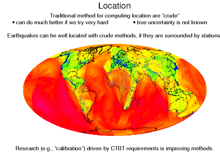
always produce a location that is close to the true location. This map shows the regions with stations from which the ISC receives
enough data to compute reliable locations using the standard methods.
The regions shaded yellow are surrounded by stations within 1000 km.
Even moderately small earthquakes or explosions in these regions will
be produce recognisable signals at stations all around the source, and
any seismologist can easily compute a reliable location. The regions
shaded orange are not as good; only earthquakes big enough to produce
large signals out to 2000 km will be detected at surrounding stations.
Red is even worse, while green is better. The situation is actually better than this maps shows. In Peru,
Algeria, Central Asia and western China, for example, I know that
networks of tens of seismic stations are operating. Unfortunately, I
have not yet succeeded in concluding arrangements for data from these
networks to be contributed to the ISC. Non-IMS stations are concentrated in regions where there is concern
about seismic hazard. This can be seen clearly in Africa, where both
earthquakes and non-IMS seismic stations are unusually sparse except
in the East African Rift Zone. Nevertheless, even by this is very
demanding standard for sufficient data, there are enough non-IMS
stations in almost all continental regions to improve locations using
our existing methods. The other way in which standard location methods are unsatisfactory is
the error estimates. It is quite routine for seismologists to be
faced with evidence that an earthquake was, say, 20 kilometres from
their computed location when they calculated a location uncertainty
only 10 kilometres. In fact, many seismologists regard as evidence
that the "whistle-blower" is ignorant. That is, the person pointing
out the discrepancy simply has shown that he or she does not
understand what location uncertainty means. As with the locations
themselves, active research programmes motivated partly by CTBT
requirements show promise of correcting this. Determining whether the source was an earthquake or an explosion is
more challenging than detecting the event and computing its location.
Partly for this reason, discrimination is beyond the mission of the
IDC. Nevertheless, data from IMS and other seismic stations still can
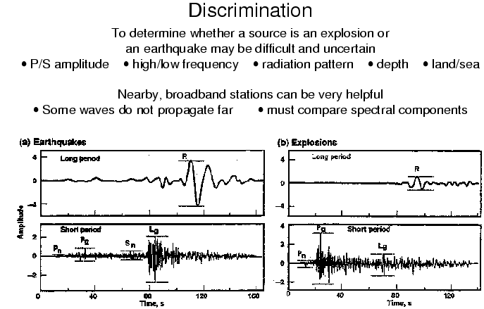
be used in discrimination. This figure, from a report by the U.S. National Academy of Sciences,
demonstrates two of the principles of discrimination. Explosions and
earthquakes each produce compressional waves and shear waves, but with
different relative sizes. At the bottom left, we see a record from an
earthquake in which the early, compressional waves are small compared
to the shear waves, which arrive later. At the bottom right, we see
the record from an explosion with the opposite pattern; the early
compressional waves are large compared to the later shear waves. The
pattern is sometimes not so clear, partly because jagged boundaries
between different types of rock within the earth sometimes convert
compressional waves from explosions into shear waves, making their
seismic records look like earthquake records. The upper frames show the same records as the lower frames, but with
the high frequencies filtered out. Low frequency waves travel along
the surface of the earth and arrive later than the high frequency
waves. But please notice that the amplitude of the low frequency wave
from the earthquake is greater than the amplitude of the low frequency
wave from the explosion. This happens because it takes time for
earthquake rupture to propagate along the fault, while the explosion
happens very quickly. To use this method requires modern "broadband"
seismic stations that are carefully sited to avoid low-frequency
noise. Even with the best seismometers, this method is less effective
for smaller earthquakes and explosions; small earthquakes rupture
shorter fault segments, so they are over more quickly and produce less
low frequency energy. I list, but do not show figures for, other discrimination methods.
Waves from explosions often are radiated with similar amplitudes in
all directions, while waves from earthquakes radiate with larger
amplitudes in some directions than in others, depending on the
orientation of the fault. Comparing amplitudes at stations in
different directions can reveal a radiation pattern that is
characteristic of an earthquake, suggesting that that particular
source is not an explosion. If the seismic waves show that the source was more than a few
kilometres deep then it was surely not a man-made explosion. Studying
the reverberations of the ground between the source and the surface
can tell us the depth quite accurately, but only if we have high
quality records from a station relatively close to the source. For each of these methods, broadband stations near the source will
provide the best evidence for discrimination, regardless of whether
the station is part of the IMS or not. Finally, I want to consider the properties of non-IMS stations in the
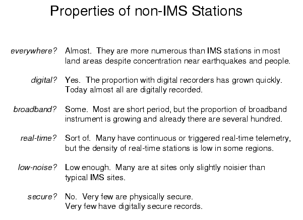
context of the goals of explosion monitoring. Are there likely to be non-IMS stations near the source? Yes. With
just a few exceptions earthquake-monitoring stations cover almost all
land areas. Is a non-IMS stations likely to have a digital recorder? Yes. Ten
years ago a seismologist from a small network might have talked
proudly about the imminent upgrade of his or her network to digital
recording. Now, digital recording is cheaper and more reliable than
recording on paper, so it is the nearly universal standard. Is a non-IMS station likely to be broadband? Not yet. Regional
networks in wealthy countries generally have broadband seismometers
and a few hundred stations in global networks are broadband. But
across large swaths of the earth, the local and regional networks are
still primarily short period. This probably will change within ten
years, but right now the most common type of non-IMS stations could
make only a limited contribution to discrimination. By the way, the
relative sparseness of broadband stations is why so many seismologists
are so keen for the CTBT Organisation to make IMS data freely
available. Are data from most non-IMS stations available in near-real-time?
Locally, yes. Most networks have a central site to which data are
transmitted. And, usually, each network centre has a connection to
the Internet. But in most cases there has been no motivation (or
funding) to build a system that routinely transmits the data on from
the regional network centre. Are most non-IMS stations at low-noise sites? Not as low-noise as IMS
stations, which are very carefully sited. But most broadband stations
have been well enough sited (or have been moved to sufficiently good
sites, if there were problems initially) that they could make a very
useful contribution, even to discrimination. Are most non-IMS stations secure? No. IMS data include the digital
signatures based on securely held private keys to guard against
spoofing, i.e., replacing real data with data recorded somewhere else
or at some other time. All seismologists guard against technical
failures and vandalism, of course. But I would regard an
earthquake-monitoring seismologist concerned that somebody might try
to spoof his or her data as clearly paranoid. I know of no records
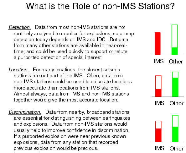
from non-IMS seismic stations with digital signatures. In this slide I have supplemented my concluding remarks with some
graphics that I hope will help to make my statements more clear. The
graphics are not quantitative. There is no scale and if another
seismologist argued with me that some of these bars should be a bit
taller or shorter, then after some discussion I might well agree with
him or her. At this time, non-IMS seismic stations do not contribute nearly as
much to Detection as IMS stations. This is not due to any limitation
of the stations, but due to the lack of using the data in an effective
way for global monitoring. It is possible to conceive of ways to use
these stations for global monitoring; I represent this possibility
with an outlined green bar. Since even short period stations are
effective for detection and there are so many of them, in almost all
land areas, non-IMS stations could (in principal) collectively provide
a better detection threshold than the IMS. At this time, non-IMS stations contribute more to earthquake and
explosion accurate Location than the IMS. The short period
instruments at most non-IMS stations are perfectly good for computing
locations, and their greater numbers are essential for achieving
accuracy. One word of caution: without a global communication system
to routinely and securely transmit data, there could be a delay of a
few days in collecting data from some non-IMS stations even when they
are most urgently required. New location methods that seismologists are developing will reduce the
gap between accuracy from the sparse IMS and the dense networks of
non-IMS stations, but even earthquake-monitoring seismologists will
take advantage of these new methods, so the greater density of their
stations will always give them some advantage. At this time, the contributions to Discrimination from the IMS and
from non-IMS seismic stations are about the same. Very high quality
stations with well-known broadband response functions are important
for discrimination, especially for relatively small events, and the
170 seismic stations of the IMS are among the best in the world. But a growing number non-IMS stations have modern instrumentation, and
within five to ten years IMS stations are likely to become a small
minority of broadband instruments in almost all land areas. It seems
obvious to me that the States Parties, who are responsible for
discrimination, will use data from the numerous non-IMS seismic
stations in discrimination.
----
next
prev
next
prev
next
prev
next
prev
next
prev
next
prev
next
prev
----